GeoJSON 面 · GeoJSON Polygon · ▶ 在线运行案例
案例合集: 三维可视化功能案例(threehub.cn)
开源仓库github地址: https://github.com/z2586300277/three-cesium-examples
**400个案例代码: ** 网盘链接
你将学到什么
- GeoJsonDataSource.load 加载 GeoJSON 面数据
- 统一设置 stroke / fill / strokeWidth
- scene.pick 点击 Entity 修改 polygon.material
- 封装
changeMaterial批量改色
效果说明
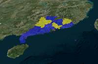
加载广东省 GeoJSON,半透明蓝色填充;点击某一区域后该区域变为黄色半透明。
核心概念
GeoJsonDataSource
const dataSource = await Cesium.GeoJsonDataSource.load(url, {
    stroke: Cesium.Color.RED.withAlpha(0.5),
    fill: Cesium.Color.BLUE.withAlpha(0.5),
    strokeWidth: 3,
});
viewer.dataSources.add(dataSource);
viewer.flyTo(dataSource);
加载后每个 Feature 对应一个 Entity,面要素带 polygon 图形。
点击改色
viewer.screenSpaceEventHandler.setInputAction((event) => {
    const picked = viewer.scene.pick(event.position);
    if (Cesium.defined(picked) && picked.id) {
        picked.id.polygon.material = Cesium.Color.YELLOW.withAlpha(0.5);
    }
}, Cesium.ScreenSpaceEventType.LEFT_CLICK);
picked.id 即 Entity;polygon.material 接受 Color 或 MaterialProperty。
批量换肤
dataSource.changeMaterial = (params) => {
    dataSource.entities.values.forEach(entity => {
        entity.polygon.material = Cesium.Color.fromCssColorString(params.fillColor)
            .withAlpha(params.fillOpacity);
        entity.polygon.outlineColor = ...;
    });
};
实现步骤
- 初始化 Viewer 与底图
setGeoPolygon(viewer, geojsonUrl)封装 load + add + changeMaterialviewer.flyTo(dataSource)定位到数据范围- 注册 LEFT_CLICK,pick 后改 material
代码要点
import * as Cesium from 'cesium'

const box = document.getElementById('box')

const viewer = new Cesium.Viewer(box, {

    animation: false,//是否创建动画小器件,左下角仪表

    baseLayerPicker: false,//是否显示图层选择器,右上角图层选择按钮

    baseLayer: false, // 不显示默认图层

    fullscreenButton: false,//是否显示全屏按钮,右下角全屏选择按钮

    timeline: false,//是否显示时间轴

    infoBox: false,//是否显示信息框

})

const url = GLOBAL_CONFIG.getLayerUrl()

const layer = Cesium.ImageryLayer.fromProviderAsync(

    Cesium.ArcGisMapServerImageryProvider.fromUrl(url)

)

viewer.imageryLayers.add(layer)


// 加载geojson数据
const dataSource = setGeoPolygon(viewer, 'https://z2586300277.github.io/three-editor/dist/files/font/guangdong.json')

// 看向geojson数据
viewer.flyTo(dataSource)

// 点击变色
viewer.screenSpaceEventHandler.setInputAction((event) => {

    const pickedObject = viewer.scene.pick(event.position)

    if (Cesium.defined(pickedObject) && pickedObject.id) {

        pickedObject.id.polygon.material = Cesium.Color.fromCssColorString('yellow').withAlpha(0.5)

    }

}, Cesium.ScreenSpaceEventType.LEFT_CLICK)

// 创建 面
async function setGeoPolygon(viewer, source, params = {}) {

    const dataSource = await Cesium.GeoJsonDataSource.load(source, {

        stroke: Cesium.Color.fromCssColorString(params.strokeColor || 'red').withAlpha(params.strokeOpacity || 0.5), // 边界

        fill: Cesium.Color.fromCssColorString(params.fillColor || 'blue').withAlpha(params.fillOpacity || 0.5), // 填充

        strokeWidth: params.strokeWidth || 3,

        markerSymbol: '?',

        ...params

    })

    dataSource.changeMaterial = (params) => dataSource.entities.values.forEach(entity => {

        entity.polygon.material = Cesium.Color.fromCssColorString(params.fillColor || 'blue').withAlpha(params.fillOpacity || 0.5)

        entity.polygon.outlineColor = Cesium.Color.fromCssColorString(params.strokeColor || 'red').withAlpha(params.strokeOpacity || 0.5)

        entity.polygon.outlineWidth = params.strokeWidth || 3

    })

    viewer.dataSources.add(dataSource)

    return dataSource

}
完整源码:GitHub
小结
- 本文提供 GeoJSON 面 完整 Cesium.js 源码与在线 Demo,建议先运行案例再改 uniform/参数做二次实验
- 更多 Cesium.js 实战案例见 three-cesium-examples 合集 与 GitHub 开源仓库